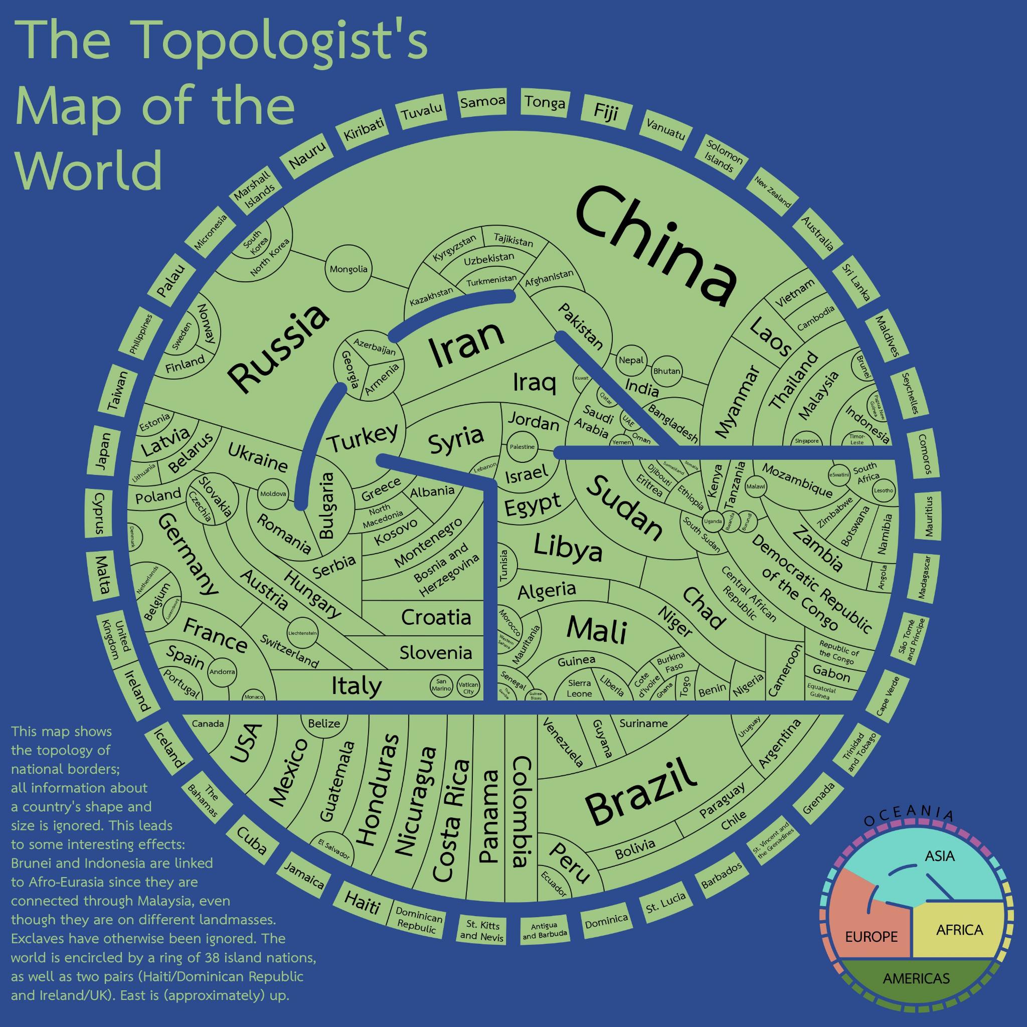
Canada now has a land border with Denmark. Have fun with that.
A community for Cartographers with nothing left to lose.
Rules:
Don't be awful Lemmy Guidelines Still Apply.
No direct upload images This is hosted on Lemm.ee- to post images, you must use an image upload service like Imgur to post maps.
We are agents of chaos I've created this to be the alternative to the community I used to manage on the website that shalt not be named "mapporncirclejerk"
Live and let die Meme trends happen, so please don't message mods asking to take down maps that are repetitive to a bit.
Reposts Vs. Covers Not all reposts are evil- if someone posts something that has been done years ago, it serves to bring old memes to the new users. I call these meme covers. However it can be done in excess which makes it a repost and spam. Mods will determine if a post is a cover or a repost.
No impersonating mods I can't believe I had to make this rule.
No harassing mods on an appeal We can talk it out, and we will be acting in good faith when making decisions. If you disagree with a removal, you are free to message for clarification or to appeal by giving some added context.
Bans Bans will be set to a maximum of 365 days for humans, and a minimum of 365 years for bots. I believe people can change, so if you are banned for good reason, do know that it is not permanent, it is just a way to say "take time to grow and come back when you are ready".
Canada now has a land border with Denmark. Have fun with that.
Small text explains that exclaves are excluded, otherwise Brazil also has a land border with France.
Had to think about this but I don't think an island is considered an exclave.
The reason for this is because it is entirely surrounded by water, not another piece of land. Islands are not usually considered to be exclaves.
https://homework.study.com/explanation/is-hawaii-an-exclave.html it's paywalled but the answer came through on google.
The island is right beside both Canadian and Denmark (greenland) land, so it's not exactly isolated or surrounded by either.
Greenland might count as an exclave itself, though.
... Not if islands are not.
Oh shit, yeah, I forget it's considered an island.
I see Indonesia borders Papua on that map, and that's the same situation. Plus, Greenland isn't treated separately from Denmark, which would be the other possibility.
Maybe they don't have data on it? /s
Edit: I'm wrong, ignore the rest of my comment. Leaving it around for the world to see my shame.
An enclave is one country's land that's completely surrounded by another country's land.
The land border between Canada and Denmark is on an island, and each country "owns" half the island. There's no enclave involved here.
"Ex" vs "en"
Oops, my bad.
It's totally arbitrary for the purposes of making the map look better. Otherwise Indonesia wouldn't be on the continent.
Also, Denmark and Sweden, via the Øresund Bridge
The vikings were far more impressive the last time.
Canadians: Look how they massacred my boy
Australia: "First time?"
Australia really didn't deserve this. She could have been in the tip of Asia where Indonesia is. Which reminds me why is Indonesia in the continent?
Yeah. Where's our border with Denmark?
I like how organized North and Central America are
First Nations peoples will remember this
I realize it could be a lot harder to organize but I'd be interested in a version of this where the size of the country corresponds to the number of countries it touches. In this version seems like we get some weird shapes/sizes just to fit everything into a circle.
This is wrong, argentina also borders bolivia and Paraguay doesn't border chile
also Brazil borders France
Would count as en exclave and the map states they ignore those, because let's be honest they'd really make this difficult.
Why is India so small on the map? I am confused by the size choices here. Is it based on neighboring nations?
Edit: ya know, I really should'a read the text.
There are several seas here: Red, Mediterranean, Black and Caspian. The Arctic and Antarctic Oceans are not represented, that'll minimize the perimeters of Canada and Russia.
Overall, this is a very intriguing visualization of the political world. Fascinating stuff. Which I'm not sure I fully understand, don't get what "topology" refers to, but to me it evokes an image highlighting different altitudes, as with mountains, valleys and coastlines.
If altitude is portrayed I don't see it. I think this map is purely to show borders/adjacency without consideration of size and only vague consideration of location. Size kinda sorta correlates with the number of adjacent countries but also seems a bit arbitrary.
This could actually be really handy if you want to do a road trip and spend as much time in customs as humanly possible.
I wonder what it would look like with embassies included
I don't get the bit about Brunei and Indonesia being linked to afro-eurasia
Malaysia has a part on the mainland and also on an island (which it shares with Brunei and Indonesia I believe)
Oh is it they should be on the outskirts of the map otherwise, as they're oceanic?
being linked to afro-eurasia
Why not? Kalimantan is part of (South East) Asia.
The biggest land border France has is with Brazil.
This is like the UK Metro map of the world.
Now do one of Middle Ages Europe