this post was submitted on 24 Feb 2025
274 points (98.9% liked)
Map Enthusiasts
3851 readers
260 users here now
For the map enthused!
Rules:
-
post relevant content: interesting, informative, and/or pretty maps
-
be nice
founded 2 years ago
MODERATORS
you are viewing a single comment's thread
view the rest of the comments
view the rest of the comments
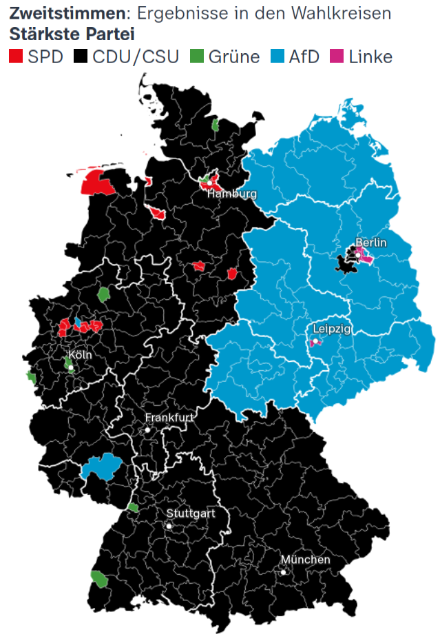
If you're wondering what the AfD districts in the West were: Gelsenkirchen in the north and Kaiserslautern in the south.
The most notable thing in Kaiserslautern is Ramstein air base and friends. I guess the military votes far-right.
I have no idea what's up with Gelsenkirchen. SPD came second with CDU just behind, so maybe it's what would be vote splitting in a dumber electoral system. As it is, the map is just a map.
You can find an interactive version here.
US Military can't vote in German elections. The only voting population involved with the military would be NATO Aircom and even that German population would be small compared to the 80%+ turnout.
Lippe which includes GFM-Rommel-Kaserne voted CDU with 27%.
Even in Grafenwöhr CDU was around 27%.
I kind of assumed there'd be lots of German servicepeople on those bases too. Interesting that it doesn't work that way.
So why do you think Kaiserslautern went AfD?
I want to say the anti American sentiment but also Kaiserslautern is the 2nd stop in Germany from France (first being Saarbrücken). So there may be anti immigration influence.
Additionally Kaiserslautern has lost a ton of manufacturing capabilities with the withdraw of Pfaff and Opel in the area may have caused many loss of jobs and general upset of the population.